Words by Bob Thomas MBE
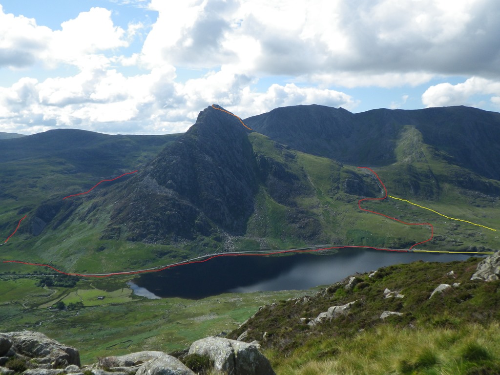
The Tryfan circuit has to be one of the UK’s most easily accessible, must do walks. The route’s easy access; outstanding views; straightforward navigation and route finding puts it within the realms of the majority of walkers.

Although the weather will ultimately dictate whether you tackle it clockwise or anti-clockwise my preferred circuit is anti-clockwise, starting and finishing at either the Idwal Cottage car park at Grid Ref. SH 649603 or the roadside parking at Grid Ref. SH 655 602

Either start has the advantage of beginning on the relatively easy ground allowing you to ease yourself into the walk. I usually park at the Car Park SH 655 602 taking advantage of the free parking and then head west for 600 metres along the road to the Idwal Car Park, to warm up and get some air in the lungs. At the Idwal car park, there are toilets and cafes, as well as a small visitor centre, where you can learn a little about the area prior to starting the walk.

Back to the walk; take the well marked path which starts next to the visitor centre and head generally south, walking slightly uphill. After 250 metres you’ll arrive at an ornate Iron Gate that marks the entrance to Cwm Idwal. Shortly after cross a small wooden footbridge and then follow the track gently uphill for 200 metres. At a prominent bend in the footpath Grid Ref. SH 651 601 a footpath heads off in a southeasterly direction. Depending on the weather conditions and the time of year this path can be a little boggy. That said, this boggy section doesn’t last for too long and soon after you break out of the marshy section and pick up the well defined path that runs parallel to the stream - Nant Bochlwyd - that flows out of Llyn Bochlwyd.
Once you’ve picked up the track begins to wind its way uphill. It’s fair to say that this is the steepest section that you’ll encounter on the circuit, but the climb, a height gain of 150 metres for 300 metres doesn’t take long, and for the most part, it’s on a well maintained path. After the uphill, the path begins to level out, with the shores of Llyn Bochlwyd but a stone’s throw away. In the middle distance, you’ll see the sheer cliffs of the Glyderau rise out of the bowl, forming a stunning natural backdrop to the Cwm.

At this stage in the walk, you have to cross the stream Grid Ref. SH 655 594, which can be quite tricky, but patience and careful rock-hopping is the key to success here, and time spent on identifying suitable stones is time well spent. Once you’ve arrived at the east bank, hopefully with dry feet, you can pick up the well defined track that leads up to Bwlch Tryfan. Once again it’s a pleasant, gradual, uphill climb for about 1 kilometre. There’s nothing too strenuous and it’s well worth taking your time so you can soak up the views and the atmosphere. There’s a lot to see: the Glyderau to the south; Y Cribin to the west; the West Face of Tryfan to the east, and if the weather is in your favour superb views north across the valley to the Carneddau and into the beautiful U-Shaped Nant Ffrancon Valley.

After negotiating the upper sections of the footpath you arrive at Bwlch Tryfan SH 661 588. There’s a dry stone wall that forms a manmade barrier between Tryfan’s southern ridge on the left, and Bristly Ridge on the right. If the winds are strong, the wall acts as a barrier from the elements, that’s perfect for using as a temporary refuge and grabbing a spot of lunch.


At this point, you can make the decision whether to continue on the circuit or make a detour and head for the top of Tryfan SH 664 593. On a clear day picking your way to the summit and returning to the Bwlch is fairly straight forward, with the majority of the route easily identifiable, but in poor visibility the descent can be a bit tricky and careful attention and mental notes must be made during the ascent to ensure that you don’t stray off the path on the descent. A fit party, in good weather, can plan on adding an additional hour to their walk should they opt to visit the summit. The additional hour spent on this detour is well worth the effort, as the south ridge offers one of the easier routes up and down to this popular peak.

Back to the circuit. From the wall, were now into the second half of the walk, 1.5 kilometres which is nearly all downhill, apart from the occasional flat section which you encounter on the valley floor. There are no real steep sections, but the path is difficult to follow at the start of the descent, becoming more obvious as you drop into the valley. Also, it’s slightly more rugged than the path which led up to the Bwlch during the first part of the walk.
Nevertheless, apart from the initial section, the navigation and route finding is simple, as long as you keep Tryfan’s east face on your left hand side, and stay on the path you can’t go wrong. As mentioned the initial section of the track can be difficult to identify and isn’t marked on the 1:25,000 map. Head generally west, then swing north west to pick up a path that contours on the Far South Peak’s south east slope. You’ll find yourself winding through heather and boulders for 300 metres, but as you descend the track becomes easier to follow eventually meeting up with the path marked on the 1:25,000 at Grid Ref SH 666 589. At this stage, the track’s direction changes to north-north-east
On the way down you’ll have a fantastic view of the east face and the Heather Terrace, and you may catch glimpses of climbers on some of the popular climbing and scrambling routes: Grooved Arete, Pinnacle Rib and Gashed Crag to name but a few. To your front, providing the weather is clear, you’ll be able to see the Carneddau to the north and the small ridgeline that forms the Crimpiau to the east. The path runs practically due north, north east for its entirety and with the end being marked by a fence, just south of a small flat section ground formed by Little Tryfan.

There’s a style over the fence here at Grid Ref. SH 670 598, and once you’ve hopped across you’ll find another good place - the aforementioned flat section - to stop for a breather on the route. Once again you’re surrounded by some fantastic scenery and there are numerous places on this little plateau where you can find a seat and tuck into what’s left of your day’s rations, at the same time glancing back from where you’ve come from and planning the final section back to the car
There are two ways to regain the car park: First is to head west then east along footpaths and tracks which run between Little Tryfan and Tryfan itself. Second, and my favourite, is to use the footpath which runs behind Little Tryfan, on its eastern side. This option may add a little more to the overall distance, but it’s easier on the feet, drier and more defined. Once again, and surprisingly, it’s not marked on the map, but it’s easy to find and the ground channels you towards it.

The track runs from the stile, generally north, and although rocky and natural at the top, has been improved and restored in the middle and lower sections. It snakes behind Little Tryfan, in a small re-entrant - leading gently downwards to where it eventually joins the main path, just north of Little Tryfan’s west face at Grid Ref. SH 671 601. From here a distinct track then continues to the farm and the Drovers Track which runs east-west along the Ogwen Valley. Don’t continue to the farm, but rather turn left at Grid Ref. SH 672603, and take the cinder surfaced Drovers track west for 500 metres towards a small copse which you’ll see in the middle distance Grid Ref SH 668605.

Eventually, you’ll arrive at a gate, with the A5 just beyond. Pass through the gate and then turn left again, and take either of the pavements which run alongside the A5. Shortly after you’ll see Milestone Buttress on your left, Llyn Ogwen on your right and Y Garn to your front. This section is perfect for cooling down, and you can take time to stretch out your legs on this section. It’s all flat and good for warming down tired muscles. Apart from keeping one eye on the traffic, no navigation is involved, and you can concentrate on absorbing the scenery which surrounds you during the final 1.3 kilometres back to the car park.
That’s the walk complete. All you need to do now is to change into some dry clothes, and if you’re not too tired complete the day with a bit of friendly banter over a cup of tea or a pint. There’s a number of Pubs, Cafes and hotels within 10 minutes driving distance of the car park at Capel Curig. My usual port of call is the Moel Siabod Cafe, in Capel Curig. The former garage has been converted into a spacious cafe with wood burning stove and varied menu. Parking isn’t a problem, and it’s a great place to unwind after a day on the hill, a cup of tea in hand and feet warming by the fire.